Erosive Factors
There is evidence that the Maltese Islands area was subject to seawater
erosive factors during the Miocene period, particularly when the area
was epicontinental and much of the land was situated in shallow waters.
Denuding agents however could play a significant role in eroding the landmass
only after the area was lifted above sea-level in the late Miocene. With
its exposure, the land could now be affected by surface and underground
waters, sea action, and climatic factors. The Ice Age cycles during
the Pleistocene also had a minor effect on the land.
SURFACE WATERS:
During the Pliocene and early Pleistocene, surface waters attributed to
a marked change in scenery. This period was marked by the Pluvial periods
coinciding with the Ice Ages. The increased rainfall, coupled to the connection
to the continent, resulted in a number of river tributaries coming from
a northern direction. 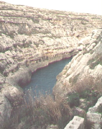 These
have left their mark in the large number of eroded valleys, included among
which are Wied il-Ghasel (Malta), Wied il-Kbir (Malta), Wied
Dalam (Malta) and Wied il-Ghasri (Gozo).
These
have left their mark in the large number of eroded valleys, included among
which are Wied il-Ghasel (Malta), Wied il-Kbir (Malta), Wied
Dalam (Malta) and Wied il-Ghasri (Gozo). 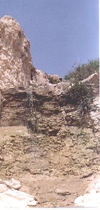 Surface
water now plays a less evident part in the Islands' present denudation.
There are presently no permanent rivers or marshes on the Islands, but
during heavy rains the valleys may be filled with torrents which carry
off soil and cause widespread destruction to the fields. Such heavy rains
are fortunately rare, but the normal rains also play an important part
in the Islands' present erosion. After a period of prolonged rainfall,
water continues to flow down defined water courses, contributing towards
their erosion.
Surface
water now plays a less evident part in the Islands' present denudation.
There are presently no permanent rivers or marshes on the Islands, but
during heavy rains the valleys may be filled with torrents which carry
off soil and cause widespread destruction to the fields. Such heavy rains
are fortunately rare, but the normal rains also play an important part
in the Islands' present erosion. After a period of prolonged rainfall,
water continues to flow down defined water courses, contributing towards
their erosion.
Rainwater falling onto soil quickly percolates through causing the
soil to become waterlogged. At this stage, the rest of the water will run
away as small streams carrying with it light matter such as clay, soil
and sand. The particle size carried is dependent on the water velocity.
Clay when dug up from deep layers is quite hard, but on the surface, it
absorbs a certain amount of water becoming impervious to more water. When
the rains fall on the surface clay, the clay quickly becomes waterlogged
and viscous. This allows landslipping of this strata and the overlying
strata, resulting in the characteristic Talus Formation of clay slopes. 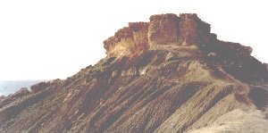 The
clay horizon never forms cliffs, but rather forms comparatively gentle
slopes on which the overlying strata is piled up in great heaps. In these
slopes are also found evidence of erosion by running surface waters causing
grooves cutting through the slopes. The undercutting of the clay facilitates
the fracturing of the overlying greensand and upper coralline limestone,
which slide down to the botton of the clay slopes.
The
clay horizon never forms cliffs, but rather forms comparatively gentle
slopes on which the overlying strata is piled up in great heaps. In these
slopes are also found evidence of erosion by running surface waters causing
grooves cutting through the slopes. The undercutting of the clay facilitates
the fracturing of the overlying greensand and upper coralline limestone,
which slide down to the botton of the clay slopes.
Surface water erosion of the soil cover is minimized by an adequate
plant cover, which helps bind soil particles together. Local farmers attempt
to preserve the precious soil by terracing their fields, thus reducing
the stream water velocity. The surface waters described above run down
usually towards the sea. When the stream enters the sea, the velocity of
the water is immediately checked causing coarser material to precipitate,
the finer mud being carried on to deeper waters. In this way a form of
delta can be formed, and probably accounts for the Greensand horizon formed
during the Helvetian series. The talus formation of the clay slopes also
"flows" downwards, and in localities near the sea, notably in the
vicinity of Slug's Bay (Malta), the clay strata may be noted to
cover the sea-bed.
 Rainwater,
helped by sea-water near the coast, falling on the non-resistant limestone
causes chemical erosion of the surface of outcropping limestone. This results
in grykes consisting of narrow grooves up to several inches deep,
a feature of the Karst phenomenon. These grykes are notable on outcrops
of coralline limestone, which being more resistant than globigerina maintains
the formation. Globigerina is too easily eroded, hence being more easily
smoothed out.
Rainwater,
helped by sea-water near the coast, falling on the non-resistant limestone
causes chemical erosion of the surface of outcropping limestone. This results
in grykes consisting of narrow grooves up to several inches deep,
a feature of the Karst phenomenon. These grykes are notable on outcrops
of coralline limestone, which being more resistant than globigerina maintains
the formation. Globigerina is too easily eroded, hence being more easily
smoothed out.
UNDERGROUND WATER:
Because the Islands are partly composed of porous limestone, percolating
rainwater finds its way into rock fissures and reaches the impermeable
clay strata. Rainwater is acidic in nature since it has dissolved in it
carbon dioxide and other gasses, and hence proceeds to dissolve away part
of the rock to form watercourses and caverns. These are very often unseen
and unsuspected at the surface, though the water occasionally finds its
way to the surface through faults or the Greensand/Blue Clay transition,
accounting for natural springs. Cave-ins of caverns have occurred, usually
causing no great damage. However on December 22, 1923 a cave at Bahrija
collapsed killing a shepherd boy. A spectacular result of such cave-ins
can be seen at Il-Maqluba to the south of Qrendi. This cave-in has
resulted in a 108 feet deep hole with a circumference greater than 1000
feet.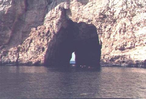 Though
to have been formed by similar processes are the inlets on the western
side of Comino and Qala Dwejra (Gozo).
Though
to have been formed by similar processes are the inlets on the western
side of Comino and Qala Dwejra (Gozo).
 Caves
due to subterranean water erosion are numerous on the Islands. The more
important ones include Ghar Hassan (Malta),
Ghar Dalam (Malta),
and the Alabaster Caves at Xaghra (Gozo).
Caves
due to subterranean water erosion are numerous on the Islands. The more
important ones include Ghar Hassan (Malta),
Ghar Dalam (Malta),
and the Alabaster Caves at Xaghra (Gozo).
Another spectacular cave of this sort is found at St. George's Bay
known as Chark El Hamien. Lying at a grid reference of 538762, this
cave is found in the fields off the old military road leading to St. Andrew's
Barracks from St. George's Bay. The cave opening is a slit-like man-made
aperture in what from afar appears to be a smooth quarry face of coralline
limestone. The opening, about 3 feet in width, leads to a small area of
stones re-enforced by concrete. This elliptical dome-shaped cave has an
overall area of just under 600 square meters, and is completely filled
with water. The water depth is generally deep except along a ledge to the
right of the cave's opening by the wall where one can progress by wading.
This ledge leads to a medium-sized area above water-level, the result of
a past fall. This is composed of lower coralline and globigerina limestone
boulders bound by smaller stones and soil. From this boulder area, leading
to about midway to the opposite wall, was a narrow path of boulders and
soil in shallow water.
The process of formation of the cave can only be speculated at, but
it is plainly obvious that the main causative factor was the action of
underground water enlarging faults and fissures, thus forming the initial
cave. Later cave-ins, as evidenced by the boulder area, further enlarged
the cave dimensions. The entrance has been created by a local fault line
breaking off at 5/10o from the vertical. This geological event
brought down with it the original cave's cumbersome overhanging roof. The
original entrance was a narrow shaft in the ceiling, but in 1772 Count
Giovannantonio Ciantar relates about the cutting of a conduit trench on
the south side facilitating entrance to the cave. This trench was cut in
an attempt to use this freshwater reservoir for irrigation purposes at
Bailiff Spinola's residence some distance away. This plan was eventually
abandoned, however recently the cave water is being pumped out for use.
Count Ciantar also relates about the passage of two "streams"
of underground water, one of which winds its way via Qormi to Marsa and
the other to Chark El Hamiem. This latter stream supposedly originated
from the hills to the west and South. This idea is based on a previous
suggestion made by Fra Girolomo Manduca who tells of a place not far from
St. Paul's Bay where sea-water is taken inland and made potable by its
passage through the rock. One wonders on what basis Fra Manduca arrived
at these conclusions of underground streams originating from sea-water.
This idea is now known to hold true for the presence of the Lower aquifer
at Sea water Level. It may also holds true for the origins of Chark
El Hamiem's water, since studies done on the cave water level showed
the water level to be roughly in unison with the sea-water level in the
bay. The water line fluctuates about 0.3 m between the dry and wet seasons,
being accounted for by different rates of evaporation.
 The
other important source of water comes from rainwater which percolates through
the fissures in the upper Coralline Limestone, and the permeable Greensand
strata to reach the impermeable Blue Clay layer. Here it forms the perched
water tables. In some areas such as Pwales, Marfa, and Comino, the Blue
Clay horizon lies below sea-level, hence the water table becomes a lower
water table.
The
other important source of water comes from rainwater which percolates through
the fissures in the upper Coralline Limestone, and the permeable Greensand
strata to reach the impermeable Blue Clay layer. Here it forms the perched
water tables. In some areas such as Pwales, Marfa, and Comino, the Blue
Clay horizon lies below sea-level, hence the water table becomes a lower
water table.
The underground waters containing dissolved carbonate continues to
slowly percolate to the cave, trickling down the cave walls and from the
cave roof. The carbonate in solution is gradually redeposited in the crystalline
form of calcite, forming stalagmites, stalactites or encrustation's over
the walls or in fissures. Spectacular results of this process may be viewed
in the Alabaster Caves of Xaghra (Gozo). Stalagmites and stalactites
can also be seen at Ghar Dalam (Malta). 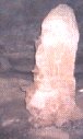 The
growth of these formations is very slow and variable, depending on the
amount of rainfall, water tapping and other factors. On average a stalactite
grows at a rate of 0.01 cm per year.
The
growth of these formations is very slow and variable, depending on the
amount of rainfall, water tapping and other factors. On average a stalactite
grows at a rate of 0.01 cm per year. 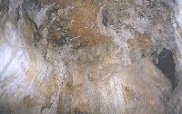 Water
action in caves also result in the formation of conical holes in the cave
roof or wall. Examples of these holes can be found in the water-formed
caves of Ghar Dalam (Malta), Ghar il-Friefet at Girgenti
(Malta) and Ghar Hasan (Malta). The roof at the latter cave shows
the conical holes and stalamitic incrustations over the walls and roof
deposits.
Water
action in caves also result in the formation of conical holes in the cave
roof or wall. Examples of these holes can be found in the water-formed
caves of Ghar Dalam (Malta), Ghar il-Friefet at Girgenti
(Malta) and Ghar Hasan (Malta). The roof at the latter cave shows
the conical holes and stalamitic incrustations over the walls and roof
deposits.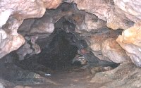 Water flow through the caves can vary through time, thus resulting in the
cutting of secondary channels with widening at the lower part of the cave
walls. This feature can be seen both at Ghar Dalam and Ghar Hasan.
Water flow through the caves can vary through time, thus resulting in the
cutting of secondary channels with widening at the lower part of the cave
walls. This feature can be seen both at Ghar Dalam and Ghar Hasan.
SEA ACTION: Another
important factor affecting erosion is the effect of the sea on the coastline.
It is now generally agreed that ocean currents play a very small part in
the erosive and transporting action of the sea. 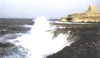 The
work of the sea is primarily through wave action, and to some extent through
the hydraulic forces engendered by the movement of great masses of water,
but far more through the arming of the waves with quantities of rock, stones,
gravel and sand. Consider what happens at the base of cliffs. Angular blocks
of rock and stones fall from the cliff face. These are picked up by the
waves and hurled against the base of the cliffs which they thus tend to
undercut. Blocks from above then split off along along joints and fall
by the force of gravity.
The
work of the sea is primarily through wave action, and to some extent through
the hydraulic forces engendered by the movement of great masses of water,
but far more through the arming of the waves with quantities of rock, stones,
gravel and sand. Consider what happens at the base of cliffs. Angular blocks
of rock and stones fall from the cliff face. These are picked up by the
waves and hurled against the base of the cliffs which they thus tend to
undercut. Blocks from above then split off along along joints and fall
by the force of gravity.
Such an occurrence occurred in the Summer of 1980 at Ghajn Tuffieha
(Malta) when a large part of the overhanging cliff fell into the sea. Where
there is a dip of the rocks seawards great masses may slide down the bedding
planes. This latter effect is best seen where rock overlies clay, the surface
of which becomes slippery and acts as a greased plane - hence the constant
slips. This undercutting and slipping result very often in large faults
close to the cliff edge, such as the ones at Rdum Rxawn (Malta).
On the shore, the rock fragments are rolled against one another and
quickly reduced to rounded boulders, pebbles and sand. These rolled backwards
and forwards by the waves, enable the sea to level off its wave action.
In addition, hard stones are whirled about by the action of the surf in
rough weather. This wears out as smooth and more or less circular excavation
in the softer rock giving rise to underwater potholes. These potholes,
by virtue of their mode of formation, are commoner in coastlines areas
composed of the soft globigerina limestone.
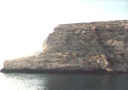
Thus the effect of the sea round the coasts may be described as the
creation of a platform or the continental shelf. This effect is more marked
to the southeast of Malta, creating the deep natural harbours of the area.
The reason behind the marked erosion of this area in mainly due to the
southeastwards tilting of Malta bringing the easily erodable limestone
to sea-level, while resulting in the high lower coralline cliffs to the
west of the Island. A very striking example of sea erosion is seen at St.
Thomas Bay on the limits of Zejtun (Malta). here the predominant strata
is the very soft and easily erodable globigerina limestone. At this site
are fields which have already been halved and old residents remember rooms
which stood about 30 meters out to sea. A large farmhouse known as "Tal-Franciz"
is gradually being destroyed by the sea, and part of the building has collapsed
with the cliff.
 In
a number of sites, such as the coast off Gnejna Bay (Malta), the platform
formed by the action of the waves has been lifted above sea-level. An these
sites, the process is very often repeated, resulting in the undercutting
of the previous platform.
In
a number of sites, such as the coast off Gnejna Bay (Malta), the platform
formed by the action of the waves has been lifted above sea-level. An these
sites, the process is very often repeated, resulting in the undercutting
of the previous platform.
The strong action of waves has also resulted in the numerous amount
of caves, grottoes and natural arches of which the Blue Grotto caves and
the caves of Dwejra are the most well known. 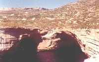 These
caves are usually found in well-jointed rocks such as Lower Coralline limestone.
In these rocks, the water is forced into crevices compressing the air trapped
within them. When allowed to expand suddenly, the air widens the crevices,
and by a continuous process enlarges them to form caves.
These
caves are usually found in well-jointed rocks such as Lower Coralline limestone.
In these rocks, the water is forced into crevices compressing the air trapped
within them. When allowed to expand suddenly, the air widens the crevices,
and by a continuous process enlarges them to form caves. 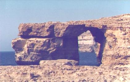 When
the action of the waves on headlands occurs from two sides, erosion occurs
equally from both headland faces. In this way a natural arch may be produced
such as the one found at Dwejra Bay in Gozo.
When
the action of the waves on headlands occurs from two sides, erosion occurs
equally from both headland faces. In this way a natural arch may be produced
such as the one found at Dwejra Bay in Gozo. 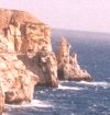 With
continued erosion, the arch may collapse leaving a stack such as the one
found at Il-Mara (Malta).
With
continued erosion, the arch may collapse leaving a stack such as the one
found at Il-Mara (Malta).
Over very large areas, the continental shelf is covered by a verneer
of sediments laid down by the sea itself. These are derived from both the
near-by land by wave action and from the smoothing of the shelf itself,
as well as from sediments brought by rain water. There is normally a gradation
from the coarse shingle and stones of the beach to sand, becoming finer
seawards, which in turn passes into silt and sand. This process accounts
for the sandy beaches of the Islands. Microscopical studies of sands collected
from various sites from the Islands showed these to be subangular to subrounded.
The sand particles are prevented from becoming exact spheres by the cushioning
effect of the sea. In contrast sands formed by the action of wind are usually
rounded, and those formed by a crushing action are angular. In addition
different forms of sand are found locally.
 The
colour and size of the sand particles depend on the bed-rock from which
they originate. Thus the sands at Ghajn Tuffieha (Malta) are of
a reddish yellow colour and of very fine texture, and are similar to the
sands from Ramla Bay (Gozo).
The
colour and size of the sand particles depend on the bed-rock from which
they originate. Thus the sands at Ghajn Tuffieha (Malta) are of
a reddish yellow colour and of very fine texture, and are similar to the
sands from Ramla Bay (Gozo). These sands contrast very well with the sandstone of the areas which has
similar properties. The sand at Mellieha Bay (Malta), on the other
hand, is coarser and of a grayish colour being similar to the sandstone
of the region.
These sands contrast very well with the sandstone of the areas which has
similar properties. The sand at Mellieha Bay (Malta), on the other
hand, is coarser and of a grayish colour being similar to the sandstone
of the region.
Broadly speaking, any stretch of coastline is either one of erosion
or one of deposition. The rate of deposition in an area is dependent on
local factors. Deposition is higher in areas where eddy currents are produced,
such as behind a spit of land. An example of such a process produced artificially can be seen at Pretty
Bay, Birzebbugia (Malta). In relatively recent years, a breakwater
built there to protect fishing boats has resulted in the bay becoming shallower
with the creation of a small sandy beach.
An example of such a process produced artificially can be seen at Pretty
Bay, Birzebbugia (Malta). In relatively recent years, a breakwater
built there to protect fishing boats has resulted in the bay becoming shallower
with the creation of a small sandy beach.
CLIMATIC FACTORS:
Denudation on the Islands of Malta has been indicasted to be mainly due
to water action on the easily eroded limestone. However other less spectacular
factors are also responsible.  Wind
action carrying small particles, sea water spray, or rain has an erosive
action on the softer limestone. The efect of wind action is to smoothen
out the globigerina limestone face, a feature best seen along the globigerina
cliff at Mtahleb.
Wind
action carrying small particles, sea water spray, or rain has an erosive
action on the softer limestone. The efect of wind action is to smoothen
out the globigerina limestone face, a feature best seen along the globigerina
cliff at Mtahleb.  When
rain-water plays an important role in erosion of globigerina, then uneven
weathering closely resembling a honeycomb notable in many old globigerina
walls and monuments.
When
rain-water plays an important role in erosion of globigerina, then uneven
weathering closely resembling a honeycomb notable in many old globigerina
walls and monuments.  This process is undoubtedly helped by the chemical solution of the rock.
Air pollution from motor cars and industrial wastes would further increase
this form of erosion. A similar effect can be seen in natural outcrops
composed of variable strata. Acceleration of weathering at the softer strata
relative to others results in the phenomenon of degradation so common on
most of the natural outcrops.
This process is undoubtedly helped by the chemical solution of the rock.
Air pollution from motor cars and industrial wastes would further increase
this form of erosion. A similar effect can be seen in natural outcrops
composed of variable strata. Acceleration of weathering at the softer strata
relative to others results in the phenomenon of degradation so common on
most of the natural outcrops.
Wind action also contributes towards altering the scenery by the
transportation of light particles of soil and sand. Such transportation,
like transportation by water, is dependent on the wind speed and particle
size. this wind action has led to the development of embryo sand dunes
on the sandy beaches of the Islands, particularly at Mellieha Bay
(Malta). Microscopical studies of sand from the dunes show this to be of
a more rounded variety.
The processes which break down the bed-rock to fine powder, be it
wind or water action, are essential for the formation of soil. This process
is very often helped by farmers by breaking down of large stones to smaller
ones, thus helping nature's forces. Other soil forming processes include
extremes of temperature. High temperatures markedly dry up the rock causing
exfoliation, while freezing of water inside the rock cracks the rock mass.
Cracking of the rock is also produced by faults and other geological movements.
Various changes then take place on the bed-rock material thus forming the
soil profile.
The formation of arches and stacks of headlands serve to show the
variety of forms which can be formed by the processes of denudation. These
form because the erosive forces are equal on both sides of the headland.
Similarly, if the forces of denudation are equal in all directions, a circumdenuded
remnant is left. This very often takes the form of an isolated conical
hill with a flat top, such as the hills of Gozo.
EFFECTS OF THE ICE AGE:
About 800,000 years ago, in the Pleistocene period, temperatures began
to fall and ice slowly advanced from the north until it covered considerable
areas in northern Europe and North America. In Europe, the ice spread mainly
from Scandinavia and the Alps over most of the North European plain. The
Ice Age was interrupted on at least three occasions by interglacial periods
when mild conditions returned. It has been estimated that the present mild
period began about 20,000 years ago. The Mediterranean region did not suffer
directly from the glaciation of the Pleistocene, but rather suffered from
a series of pluvial periods. It is evident therefore that evidence of past
glaciation in the Maltese islands is not to be found. Instead we have with
us marked remains resulting from the effects of denudation by water - surface
and underground. The most noted of these effects are the large number of
valleys found on the Islands. In addition, the large number of caves caused
by underground water probably date to this period. This same period, because
of the increased rate of denudation, also saw the development of the soil
cover. An erosive factor which must have been prevalent during the pluvial
periods, was the action of freezing and expanding waters in joints and
fissures. An interesting effect of this low temperature denudation has
been described by Prof. J. Borg (1936). it has already been noted that
in coastline areas composed of the soft globigerina limestone, the action
of the surf carrying small stones results in the formation of smooth near-circular
underwater potholes. These potholes are common at the Sliema front. A number
of these, now unfortunately filled up and covered to widen the road, showed
a number of deep fissures radiating from the hole. these fissures extended
to distances varying from 1-8 meters, and were filled up with a crystalline
deposit of calcite. These fissures were the result of the enormous expanding
force of freezing water collected in a receptacle of some depth.