Tectonic Phenomenon in the Maltese Islands
Global Tectonics:
It is generally accepted that the Earth was originally a hot, gaseous mass,
which cooled down to a liquid state, and eventually formed a solid crust
on its surface. Much remains to be discovered about the Earth's crust and
interior, but present evidence shows that the land masses consist mainly
of relatively light igneous rocks, which are often covered by sedimentary
and metamorphic rocks. Beneath this light igneous rock are denser igneous
rocks which also form much of the ocean floor. The density of the rocks
progressively increases with depth, as does temperature.
 The
Earth's core, which is probably mainly metallic, is in a molten state in
spite of the enormous pressures to which it is subjected. The earth thus
consists of a liquid core (which may have a small solid core) with a radius
of about 2170 miles; a mantle about 1800 miles and a crust. The crust differs
in thickness and composition below the oceans and continents. The crust
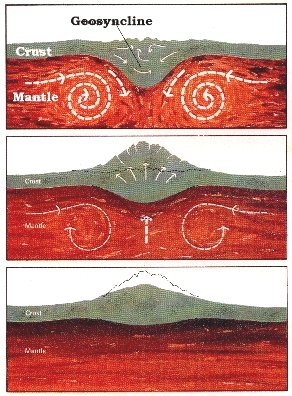
as a whole is lighter than the mantle, and therefore tends to ride over
it, driven by convection currents in the mantle. It has been suggested
that these convection currents have in the geological past fractured the
crust, resulting in a number of continental plates. Sets of these plates
spread apart at the ocean ridges where new igneous material rises to the
surface from the underlying mantle. Individual plates slide past one another
along large transfer faults as they more at different rates away from the
ocean ridges. Where they reach the adjacent continents, the oceanic material
descends beneath the marginal parts of the continental crust, pushing up
mountain chains and island arcs.
The
Earth's core, which is probably mainly metallic, is in a molten state in
spite of the enormous pressures to which it is subjected. The earth thus
consists of a liquid core (which may have a small solid core) with a radius
of about 2170 miles; a mantle about 1800 miles and a crust. The crust differs
in thickness and composition below the oceans and continents. The crust
as a whole is lighter than the mantle, and therefore tends to ride over
it, driven by convection currents in the mantle. It has been suggested
that these convection currents have in the geological past fractured the
crust, resulting in a number of continental plates. Sets of these plates
spread apart at the ocean ridges where new igneous material rises to the
surface from the underlying mantle. Individual plates slide past one another
along large transfer faults as they more at different rates away from the
ocean ridges. Where they reach the adjacent continents, the oceanic material
descends beneath the marginal parts of the continental crust, pushing up
mountain chains and island arcs.
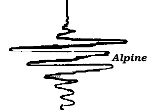
 The
development of the Alps and the submarine elevation on which the Maltese
Islands stand are the result of this process. The same mechanism was also
responsable for the different rock strata found on the Islands. The Mediterranean
area is one of the oldest synclinal depressions of the earth's crust. During
the Oligocene and Miocene periods of the Cenozoic, the area was markedly
effected by the Alpine cycle of earth movements. The third episode of the
Alpine movements caused a fluctuation in sea-depth of the Islands' area
hence resulting in different forms of rock strata. This same episode also
resulted in the formation, filling and folding of the molasse foredeep.
During the late Miocene (Samartian series), the area was again affected
by Alpine movements. The fourth episode caused a progressive uplift of
the body and forelands of the Alps, expelling the sea completely from the
area. This uplift was marked by periods of stability, and even at times
of sinking back. This episode of the Alpine cycle also saw the development
of the elevation connecting the Maltese archipelago to Europe and Africa.
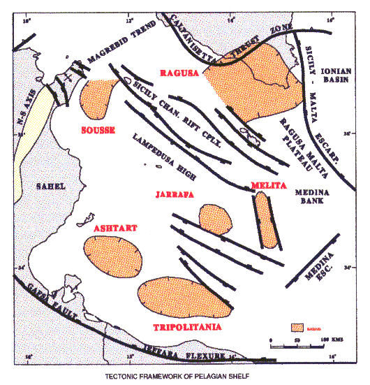
Further techtonic activity in the region gave rise to a series of regional
fault structures. The tectonic framework of offshore Malta belongs to that
of the Pelagian domain and is the result of complex interactions between
the African and Eurasian plates since the Triassic.
The
development of the Alps and the submarine elevation on which the Maltese
Islands stand are the result of this process. The same mechanism was also
responsable for the different rock strata found on the Islands. The Mediterranean
area is one of the oldest synclinal depressions of the earth's crust. During
the Oligocene and Miocene periods of the Cenozoic, the area was markedly
effected by the Alpine cycle of earth movements. The third episode of the
Alpine movements caused a fluctuation in sea-depth of the Islands' area
hence resulting in different forms of rock strata. This same episode also
resulted in the formation, filling and folding of the molasse foredeep.
During the late Miocene (Samartian series), the area was again affected
by Alpine movements. The fourth episode caused a progressive uplift of
the body and forelands of the Alps, expelling the sea completely from the
area. This uplift was marked by periods of stability, and even at times
of sinking back. This episode of the Alpine cycle also saw the development
of the elevation connecting the Maltese archipelago to Europe and Africa.
Further techtonic activity in the region gave rise to a series of regional
fault structures. The tectonic framework of offshore Malta belongs to that
of the Pelagian domain and is the result of complex interactions between
the African and Eurasian plates since the Triassic.
The principal tectonic phases are:
| Triassic-Early Jurassic |
Breakup of Pangea |
| Middle Jurassic - Early Cretaceous |
Divergence and formation of Tethys |
| Cretaceous - Eocene |
Plate Convergence and Collision |
| Eocene - Recent |
Consumption of African and European Continental margins |
| Late Tertiary |
Dextral movement of Europe with respect to Africa gave rise to renewed
rifting |
The area was a stable promontory of the African continental margin
throughout this
tectonic regime. Opening of the Ionian Sea along the Sicily-Malta
escarpment began in
Late Triassic-Early Jurassic time as a result of the sinistral movement
of the European
plate. This gave rise to the NNW-SSE trends in the Ragusa basin,
Melita basin and other
pull-apart basins of the area. Tectonism in the western Pelagian
was also controlled by
movements of Late Triassic/Jurassic evaporites. Subsequent dextral
movement of Europe
in latest Tertiary time gave rise to renewed extensive rifting and
formation of pull-apart
basins across the area. This produced a second major tectonic trend
in the area: the
NW-SE trending Plio-Quarternary Sicily Channel rift complex which
extends from
Pantelleria to the Medina Bank.
|
Era
|
Period
|
Approximate duration (years)
|
Cycles of Earth movement
|
Years ago in millions
|
|
TERTIARY or CENOZOIC
|
Pliocene
Miocene
Oligocene
Eocene
|
65,000,000
|
|
10
25
40
65
|
| |
Cretaceous
|
55,000,000
|

|
120
|
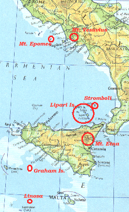
Earthquakes: The
stresses caused by the movements of the oceanic crust builds up energy
which is released through seismic activity. The Maltese Islands are completely
composed of sedimentary rocks, and no evidence of igneous rock has been
found. The Islands are however surrounded by a number of active or dormant
volcanoes. To the north are Mt. Etna (Sicily); the volcanic islands of
Stromboli and the Lipari Islands; Mt. Epomeo (Ischia, Bay of Naples); and
Mt. Vesuvius, Mt. Albani and the Phlegraean Camps (Italian Mainland). To
the northwest of the Maltese Islands lie the submarine Graham volcano and
the young volcanic island of Panteleria. To the southwest are the volcanic
islands of Linosa and Lampione; while much further away to the east is
the Santorin volcano.
Some recorded earthquates which have in the past affected the Maltese
Islands were accompanied by volcanic eruptions. In January 1692, an earthquake
felt in Sicily and Malta was accompanied by the eruption of Mt. Etna. A
previously quiescent Mt. Etna let off huge volumes of smoke during the
widespread earthquake of October 1856 On September 1911, a locally felt
earthquake appeared to have an epicenter in the region of Graham volcano
or Pantelleria. Another earthquake with possible volcanic eruption occurred
in January 1923. This earthquake was accompanied by a rumbling noise coming
from a northerly direction. Flashes of "lightning" were noticed
on the sea. The cause was attributed to a disturbance between Malta and
the Ionian Islands. Volcanic quakes are normally due to the sudden release
of steam or other volcanic gases under pressure and accompany volcanic
eruptions. Their origin may lie at considerable depths under the sea and
are then termed crypto-volcanic. The above recorded quakes could possibly
have been volcanic in origin. However the volcanoes in question are situated
a fair distance from the Maltese Islands, and it is very unlikely that
their effects would be felt locally. It is more probable that the earthquakes
were tectonic in origin, and the volcanic eruptions were the result of
the widespread earthquakes in the region.
It would therefore appear that earthquakes felt in the Maltese Islands
owe their origin to Global Tectonics. Earthquakes in the immediate region
of the Maltese arcipelago are rare, and rarer still are earthquakes of
sufficient magnitude to cause extensive damage. This is very surprising
since the Mediterranean region is an active area due to the young age of
the surrounding mountain ranges in one of the earth's oldest synclinal
depressions. Though earthquakes may be a rare occurence in the Maltese
archipelago, the disturbances arising from them may occur more frequently
than originally thought. One such disturbance is a change in sea-level.
In the destructive earthquake of 1692, the sea at Xlendi (Gozo) is supposed
to have receeded a whole mile and then rushed back again causing further
damage. A sudden recession of water on the shoreline, followed by a giant
wave indicates a "tsunani", resulting from an earthquake with a
magnitude of at least 6.5 on the Richter's scale. A tsunani may occur without
the obvious accompanment of a tremor, and may not be identified with a
tectonic origin. Such an occurrance took place on the night of July 9,
1973. Fishermen and residents in the Salina Bay area (Malta) reported a
marine disturbance, which old fishermen called "il-milghuba", and
which was alleged to have occurred a few years previously. At about 3 am,
the sea level went down by couple of feet. A short while later, the sea
rose a couple of feet above the normal level, before settling down to its
original level. Some boats, especially those anchored in shallow water,
were seen resting on the seabed. When the sea rose again, a "rumbling
noise" was heard by several people in the area, and the resulting wave
covered up normally dry land up to 400 feet inshore. Mt. Etna in Sicily
was reported to be very active a few days before.
Regional Tectonics:
Tremors in the Maltese Islands are not solely due to tectonic factors.
Localised tremors of variable magnitude may be caused by local geological
events, such as cave-ins of subterranean hollows - such as the cave-in
at Bahrija (Malta) which killed a boy and several sheep in 1923; and landslips
- such as that which occurred at Ghajn Tuffieha (Malta) in 1980.
The effects of tectonic phenomenon are very often seen in the rock
strata in the form of flexures and fractures. The whole island of Malta
appears to be in a process of sinking, this being more pronounced on the
eastern side. This has resulted in a southeastwards tilting of the Island,
raising the cliffs of the western coast and giving the deep harbours on
the eastern side. This tilting may be assumed from the constant dip of
the strata towards the east and northeast of the Island. The marked sinking
on the eastern side can be noted from the existence of "cartruts"
running along the rocky bottom of the sea for some distance from the shore
at the inlet of St. George's Bay at Birzebbugia (Malta). It is further
confirmed by the report that during the laying of the Grand Harbour breakwater
foundations, divers detached stalagmites from the bottom of the sea. Stalagmites
are formed in caves by the redeposition of dissolved limestone in water.
This suggests that the area was at one time above sea-level. If Malta continues
to sink, the Island will eventually become smaller and more elongated.
Regional Tilts also occur locally. Hence for example, the stratification
of the larger island of the St. Paul's Islands group shows a tilt with
a dip of about 12o. Regional tilts may also be responsible for
the presence of raised beaches round the Maltese coast. The erosive properties
of waves result in platform formation of the rock strata. At some sites,
the formed platform appears to have been lifted above sea-level - an effect
which is probably accounted for by regional tilts. On a regional dip may
be found wrinkles and folds which may have been present before or formed
at the same time as a consequence of the tilt. A terrace may be described
as a local lessening of the inclination in an otherwise uniformly tilted
series, while a local steepening of an inclination is termed a monocline.
The various combinations of folds may result in wave-like upwraps (anticlines)
or downwraps (synclines) as independant or complimentary structures. Geological
investigations have shown that gentle synclines and anticlines do exist
in Malta, the Mizieb syncline being the largest completely closed basin
structure known in the Maltese Islands. A striking example of a combined
anticline - syncline formation in stratified Upper Coralline Limestone
can be seen on the road from Rabat to Mtarfa. This formation is only an
example of pseudo-folding, and is not purely tectonic in origin. It very
probably owes its origin to the dissolving properties of local limestone.
Fractures are the result of some applied stress, and are never formed
accidentally or without due cause. They are classified according to the
direction of the stress. Joints are fractures in the earth's crust along
which movement has been normal to the fracture surface. This movement is
analogous to a pulling or tearing movement. It may be the result of desiccation;
temperature, mineral or physical changes; or due to an active dynamic stress.
Fractures along which some movement has occured parallel to the plane of
fracture are termed faults. This involves a shifting or sliding displacement,
wherein the masses of rock on opposite sides of the break ride by one another
in a shearing action. This action may smoothen and polish the rock surfaces
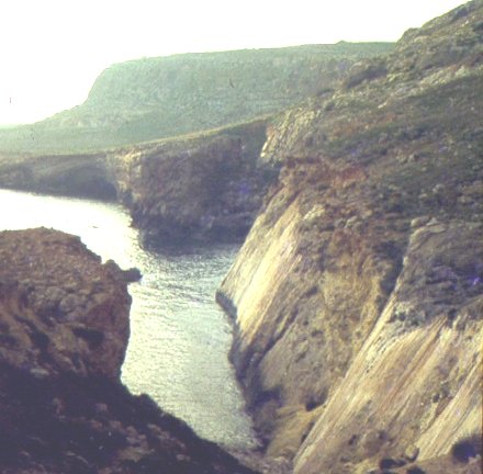
resulting in slickensides. A very good example of slickenside in Malta
can be seen along the coast from the cliffs under Mnaidra to Lapsi along
the Maghlaq fault. Fracturing may also involve extensive crushing of the
fault sides, the fissure being later filled by what is termed fault breccia.
A major fault structure is usually developed not by one break alone, but
instead comprises several individual fractures. Each is a component part
of the whole. Very often, faults are not isolated phenomenon but follow
each other at irregular intervals in the same direction forming parallel
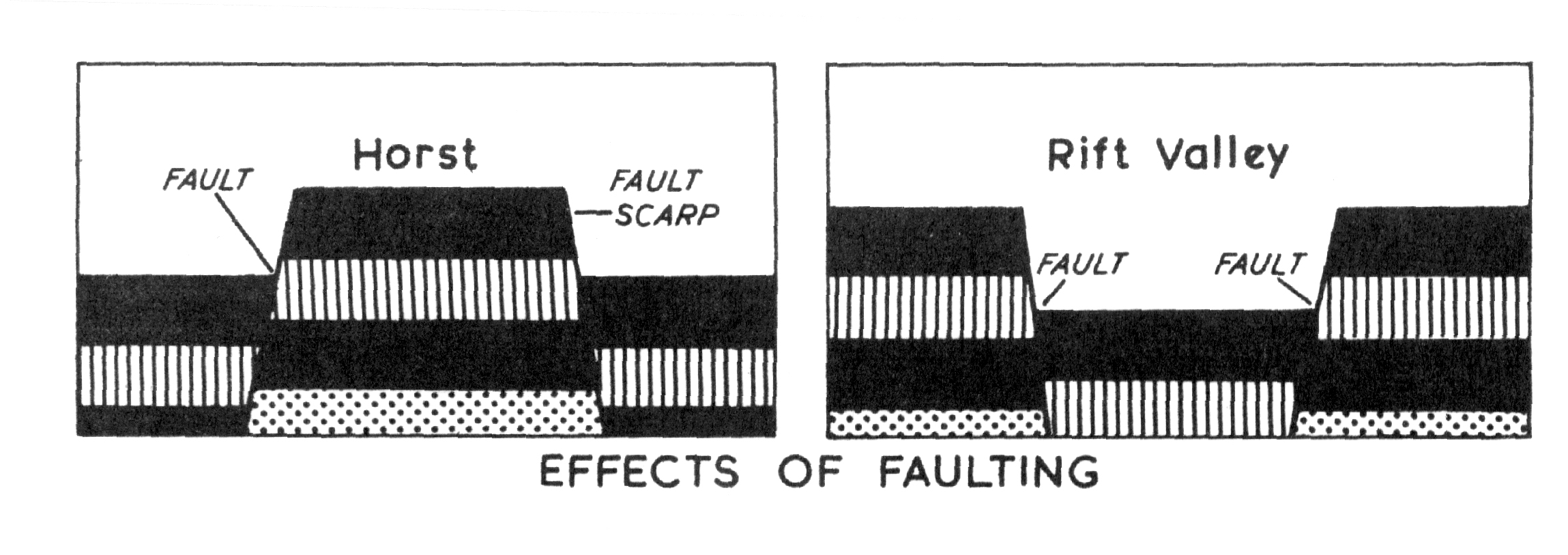
sets or step-faults, one adding to the dislocation of the other. A portion
of land may be displaced in relation to the faultlines. Thus an upward
displacement to form a plateau is termed a Horst, while a downward displacement
is termed a Grapen or Rift Valley.
Faults are classified according to the direction and angle of movement.
Thus a normal fault is one wherein the handing wall has apparently moved
downward with respect to the footwall. A movement in the upward direction
results in a reverse fault. The fault angle may also be used to sub-classify
faults. Faults whose plates are inclinded at 45o or less from
the horizontal are termed low-angled faults, while faults inclined at more
than 45o to the horizonatal are termed high-angled faults.
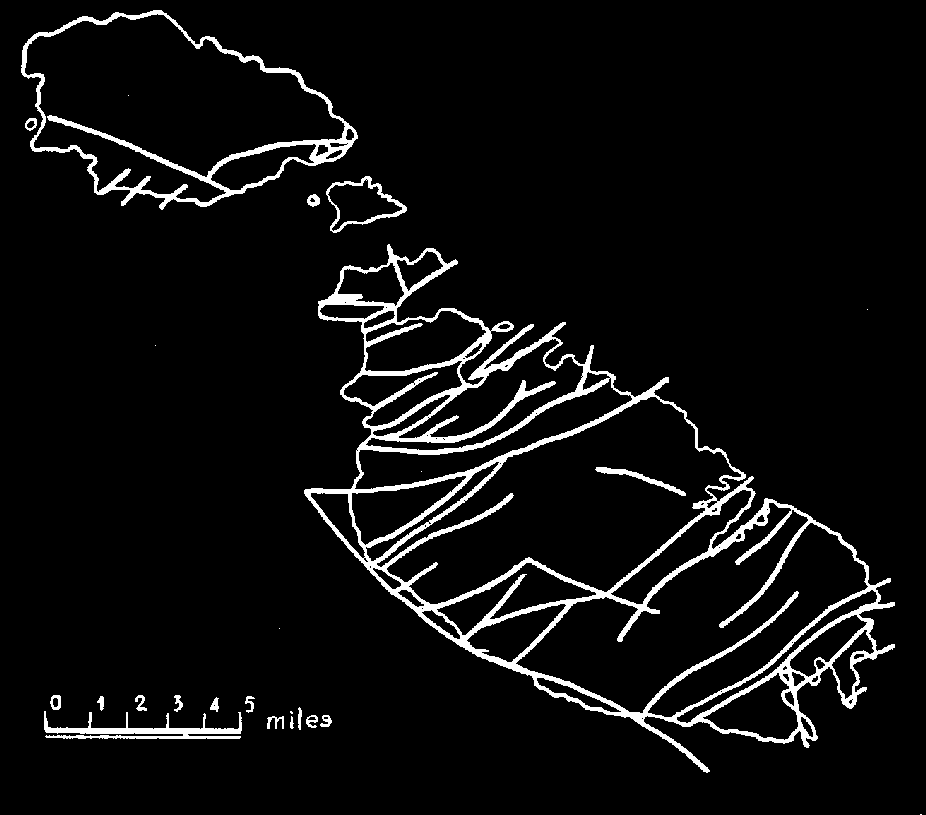
The Maltese Islands are cut up into small portions by numerous faults
of varying importance. These were first enumerated by C. Rizzo (1932).
In general, it may be stated that there is a principal fault from which
the more important faults of the Maltese Islands proceed almost parallel
to one another.
 The
principal fault <Maghlaq fault> is thought to start from the
Hurd Bank to the east of Malta off Benghisa Point, proceeds in a northwest
direction along the southwest coast of Malta, cutting off a slice of the
coast in the region of Lapsi (Malta). This fault accounts for the fact
that while Filfla is composed of Upper Coralline Limestone, the coast of
Malta in the same region is made up of Lower Coralline and Globigerina
Limestones. After crossing the continuation of the Great Fault off Ras
Ir-Raheb (Malta), the Maghlaq Fault is believed to continue in a northwest
direction to a point off Dimitri Point (west of Gozo). The same tectonic
force which resulted in the Maghlaq Fault also resulted in other faults
running almost parallel to this fault. The most important of these secondary
faults is the Grand Fault of Gozo running from Mgarr ix-Xini to Dwejra.
The
principal fault <Maghlaq fault> is thought to start from the
Hurd Bank to the east of Malta off Benghisa Point, proceeds in a northwest
direction along the southwest coast of Malta, cutting off a slice of the
coast in the region of Lapsi (Malta). This fault accounts for the fact
that while Filfla is composed of Upper Coralline Limestone, the coast of
Malta in the same region is made up of Lower Coralline and Globigerina
Limestones. After crossing the continuation of the Great Fault off Ras
Ir-Raheb (Malta), the Maghlaq Fault is believed to continue in a northwest
direction to a point off Dimitri Point (west of Gozo). The same tectonic
force which resulted in the Maghlaq Fault also resulted in other faults
running almost parallel to this fault. The most important of these secondary
faults is the Grand Fault of Gozo running from Mgarr ix-Xini to Dwejra.
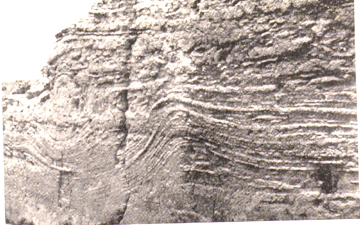
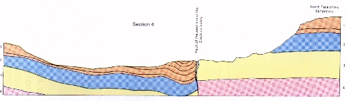 diagramatic cross-section
of the Great Fault (after Spratt, 1854)
diagramatic cross-section
of the Great Fault (after Spratt, 1854) |
Extending from the Maghlaq fault at right angles to it, are the more
important of the faults of the Islands. The most conspicuous of these faults
is the Great Fault (Victoria Lines). starting at Madliena Bay (east
of Malta), this fault crosses the Island in an east-west direction to meet
the Maghlaq Fault in the west of Malta. In Gozo too, running from the Grand
Fault of Gozo, is another major fault running in an east-west direction
parallel to the Victoria Lines. Between these two parallel faults are a
sequence of step faults, which have cut the area up into a system of "semi-Horsts"
and Graben. Thus the inner side of the land between the faults has formed
a plateau, while towards the outer side a Graben has resulted, the deepest
of which is the Straits of Comino. Tectonic features are also present towards
the southeast of Malta, however they are here less pronounced. The southeastern
area of Malta is noteworthy because of the sea-inlets running in a northeast-southeast
direction resulting from a system of parallel faults.
In Malta the main faults include:
1. The Maghlaq Fault
2. The Grand Fault (Victoria Lines)
3. The shattered zone between the Maghlaq and Grand Faults of
Malta
4. The Buskett - Siggiewi Faults:
...a. Buskett Fault
...b. Ghajn il-Kbira Fault
...c. Girgenti Fault
...d. Wied Silleni Fault
...e. Mgarr Ilma fault
5. The Marsaskala Fault
Faults in Gozo include:
1. Ta' Cini/Mgarr ix-Xini - Xlendi Fault
2. Xlendi - Rabat Fault
3. Dwejra Fault
4. Qawra Fault
5. Belliegha Fault
6. Wied Sara - Harrax - Goliath Fault
7. Dahlet Qorrot Fault.
References:
1. Hyde HPT. Geology of the Maltese Islands.
Lux Press, Malta, 1955, +135p.
2. Rizzo C. Report on the Geology of the Maltese
Islands. Government Printing Office, Malta, 1932
3. Ventura F., Galea P. The 1693 Earthquake in the
context of Seismic Activity in the Central Mediterranean Region. In: Mdina
and the Earthquake of 1693 (Azzopardi J. ed). Heritage Books, Malta,
[1994], p.5-23
4. Reuther CD. Tectonics of the Maltese islands. Centro,
1(1):1020, 1984
5. Spratt T.A.B. On the Geology of Malta and Gozo.
Malta, 1854
6. Oil Exploration in Malta: Government of Malta Homepage,
1999.