
 |
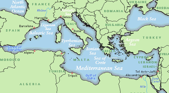
The Mediterranean Sea is
divided into two deep trenches - the Western basin and the Eastern Basin
by a submarine shallow sill across the Strait of Messina. The Maltese Islands
geographically belong to the Eastern Basin and are situated on the submarine
ridge about 60 miles to the south of Sicily and about 60 miles to the eastern
side of the ridge. Maltese territorial waters extend to 9.65 km (6 miles)
from the coast, comprehending an area of about 3000 km2 (about
1500 sq miles). Malta's fishing limits extends to 19.3 km (12 miles). In
1978, an ammendment to the Territorial Waters and Contiguous Act exended
the fishing limits to 40.2 km (25 miles) from the Maltese coastline. 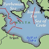 The close vicinity of the Maltese Islands to other countries has resulted
in disputes with neighbouring lands, particularly Libya, over the division
of the sea-bed. Malta initially claimed equal division of the sea areas
on the south and southeast of the Islands irrespective of Libya's longer
coastline. This claim included an area extending to 160 km (100 miles)
southwards. This dispute was settled by the International Court at Le Have
in Holland, which set the new median line by taking a line equidistant
from the low-water mark off the coast of the two countries and moved it
to 28.8 km (18 miles) closer to Malta. Thus the Maltese sea-bed in the
south extends to 131.2 km (82 miles). The Maltese sea-bed to the north
extend to the median line between Malta and the Sicilian coast, thus extending
to 46.5 km (30 miles) north.
The close vicinity of the Maltese Islands to other countries has resulted
in disputes with neighbouring lands, particularly Libya, over the division
of the sea-bed. Malta initially claimed equal division of the sea areas
on the south and southeast of the Islands irrespective of Libya's longer
coastline. This claim included an area extending to 160 km (100 miles)
southwards. This dispute was settled by the International Court at Le Have
in Holland, which set the new median line by taking a line equidistant
from the low-water mark off the coast of the two countries and moved it
to 28.8 km (18 miles) closer to Malta. Thus the Maltese sea-bed in the
south extends to 131.2 km (82 miles). The Maltese sea-bed to the north
extend to the median line between Malta and the Sicilian coast, thus extending
to 46.5 km (30 miles) north.
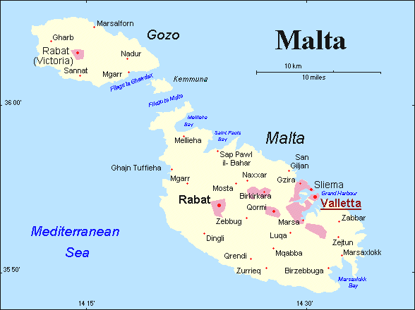
The Archipelago consists
of three main inhabited islands - Malta, Gozo and Comino - together with
some very small barren and uninhabited islets and rocks. The total area
is 315.6 km2 (122 sq mi). The larger island - Malta has an area
of 245.7 km2, and is made up of a low plateau which descends
gradually to the plain in the south-eastern part of the island. The longest
distance in Malta from the south-east to the north-west is 27.3 km, and
the widest distance is 14.5 km in an easter-westerly direction. The coastline
is well indented with harbours, bays, creeks, sandy beaches and rocky coves.
The length of the Maltese shoreline is 136.8 km.
|
|
|
km |
km |
km |
| MALTA |
|
|
|
|
| GOZO (Ghawdex): situated about 8 km to the northeast of Malta |
|
|
|
|
| COMINO (Kemmuna): lies between Malta and Gozo, about 2 km to the northwest of Malta and 1 km to the southeast of Gozo |
|
|
|
|
| COMINOTTO (Kemmunett): islet-rock on the west side of Comino. Larger islet of a string of islet-rocks forming the outer border of the Blue Lagoon. |
|
|
|
|
| ST. PAUL'S ISLANDS (Il-Gzejjer ta' Selmun): two small islets joined by a sea-level natural landbridge on the northern side of St. Paul's Bay to the northwest of Malta. |
|
|
|
|
| MANOEL ISLAND: a small island within Marsamxetto Harbour cut from the mainland by a passage only a few metres wide, not connected by a permanent bridge. |
|
|
|
|
| FILFLA: a tiny islet-rock about 3 km off the south coast of Malta. It tails an even tinier islet on its western side. |
|
|
|
|
Malta's sister island -
Gozo or Ghawdex - lying just 8 km to the north-west covers about 67.1 km2,
and has a maximum distance and width of 14.5 km and 7.2 km respectively.
The shoreline length measures 45 km. Comino or Kemmuna is about 2.8 km2.
The small uninhabited islets are each less than 10 ha. Both main islands
are tilted seawards to the north-east. There are no mountains, the highest
point in the west of Malta near Dingli Cliffs being 253 m above sea level.
In Gozo the highest point is in the northwestern part near Ta' Dbiegi at
191 m. There are also no lakes, rivers or streams, but only minor springs.
A series of low hills with terranced fields on the slopes characterise
the islands.
 |
The Maltese Islands are composed of a block of Oligo-Miocene limestones and marls with very subsidiary Quaternary deposits. The Oligo-Miocene succession is a simple "layer-cake" arrangement of Lower and Upper Coralline Limestones with intervening layers of soft Globigerina Limestone, Greensand and Blue Clay. Subsequent faulting, land movement and erosion has resulted in a marked diversity in relief and landform in spite of the small size of the Islands. Malta has three main regions: (1) the Rabat-Dingli Uplands on the lower west side, (2) the Parallel Ridges and Valleys on the northern side, and (3) the Hills and Plains on the eastern and south sides. The common boundary of the three main natural regions of the Malta is the Great Fault (known as the Victoria Lines after part of the fault was strengthened with a defence wall to enhance the natural line of fortifications by the British) which runs across the Island in a east-west directon from Fomm ir-Rih to Madliena. Gozo may be considered to be composed of two regions comprising the Uplands, mostly on the northern side, and the low-lying Plains and Hills, mostly on the south side.
The old capital of Malta
(Mdina) was situated in the center of the Island on the Rabat-Dingli Uplands.
The maritime Knights of St. John of Jerusalem in the 16th century established
a new capital (Valletta) in the southeast on a peninsula separating an
inlet which serves as an excellent natural harbour. The capital of Gozo
(Victoria) remains in the central part of that Island. Both Islands are
densily populated with an average density of about 1140 persons per km2
(2950 per sq mile).
![]() Related
Topics:
Related
Topics:
Geographical evolution of
the Maltese Islands
![]()