Geographical Evolution
 Introduction:
The
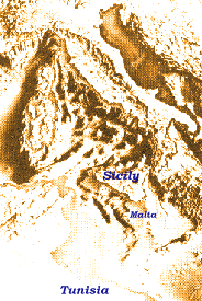
Maltese Archipelago situated almost a the center of the Mediterranean,
bearing 35o54'N 14o28'E, stands on a submarine shallow
elevation [the Malta-Ragusa Rise] which extends from the Ragusa peninsula
of Sicily and continues southwards to the African coasts of Tunisia
and Libya. The sea between the Maltese Islands and Sicily reaches a maximum
depth of not more than 200 m and is mostly less than 90 m. The area between
the Maltese Islands and the African coast is very much deeper, at places
reaching depths of up to 1000 m. Geophysically the Maltese Islands are
associated with the Hyblean Plateau of southeastern Sicily, a region generally
regarded as forming part of the African continental plate. The Maltese
Islands are small together occupying no more than three hundred kilometers
square. They lie about sixty miles south of Sicily, and about sixty miles
from the eastern side of the elevation.
Introduction:
The
Maltese Archipelago situated almost a the center of the Mediterranean,
bearing 35o54'N 14o28'E, stands on a submarine shallow
elevation [the Malta-Ragusa Rise] which extends from the Ragusa peninsula
of Sicily and continues southwards to the African coasts of Tunisia
and Libya. The sea between the Maltese Islands and Sicily reaches a maximum
depth of not more than 200 m and is mostly less than 90 m. The area between
the Maltese Islands and the African coast is very much deeper, at places
reaching depths of up to 1000 m. Geophysically the Maltese Islands are
associated with the Hyblean Plateau of southeastern Sicily, a region generally
regarded as forming part of the African continental plate. The Maltese
Islands are small together occupying no more than three hundred kilometers
square. They lie about sixty miles south of Sicily, and about sixty miles
from the eastern side of the elevation.
Pre-Miocene Evolution:
The geographical state of a small area at any particular period can be
generally deduced from the rock formation making up the area, coupled with
paleontological studies. In the absence of specific data the evolution
of a region may be extrapolated from palaeogeographical studies of the
Mediterranean. The Pre-Miocene evolution of the area occupied by the Maltese
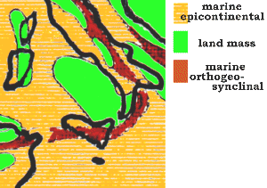
Islands is summarised in Table 1. The table defines two states, both marine.
Marine epicontinental is a state where the Islands' area forms part of
the continental shelf found around most lands up to a sea depth of 6000
feet, whereas marine orthogeosynclinal is a state where the Islands' area
forms part of the continental slopes at depths greater than 600 feet.
That Malta has been a region of continued carbonate sedimentation
for a considerable period prior to the Miocene is illustrated by the borehole
sunk by the British Petroleum Co. Ltd., at Naxxar (4974) Malta in 1959.
Commencing at the top of the Lower Coralline Limestone, the hole terminated
at a depth of 3000 meters in dolomites, which carried spores of Lower Cretaceous
affinity. Higher Cretaceous and Eocene rocks were also dolomitized limestones.
The uppermost 650m, of shelly limestones and subordinate shales, was referred
to the Oligocene.
TABLE 1: PRE-MIOCENE EVOLUTION
|
PERIOD
|
TIME SCALE
million years
|
GEOGRAPHICAL STATE
|
| Oligocene |
25-40
|
Marine epicontinental
|
| Eocene |
40-65
|
Marine epicontinental
|
| Cretaceous |
65-120
|
Marine epicontinental
in Valendian or Albian Series
|
| Jurassic |
120-150
|
Marine orthogeosynclinal
|
| Triassic |
150-190
|
Marine orthogeosynclinal
|
| Permian |
190-220
|
Marine epicontinental (?)
|
| Carboniferous |
220-280
|
Marine epicontinental
Development of foredeep;
Tethys assumes ultimate shape until Triassic.
|
| Devonian |
280-320
|
Marine orthogeosynclinal
|
| Silurian |
320-350
|
Marine orthogeosynclinal
|
| Ordovician |
350-400
|
Marine orthogeosynclinal
|
| Cambrian |
400-500
|
(?)
|
| Pre-Cambrian |
>500
|
(?)
|
Miocene Evolution:
The evolution of the Islands during and after the late oligicene is written
in the rock formations composing the Islands. Geologically the Islands
are chiefly formed of sandstone, clay and limestone, the sequence being
summarised in Table 2.
TABLE 2: MIOCENE EVOLUTION
[(***): not represented unless residual clays;
(?): unknown, possibly sedimentary]
| PERIOD |
TIME SCALE
|
SERIES |
FORMATION |
| Pliocene |
11 million years
|
(***)
|
|
| Miocene |
25 million years
|
Samartian
Tortonian
Helvetian
Schlier
Burdigalian
Aquitanian
|
(***)
UCL
GNS
BC
GLB
LCL
|
| Oligocene |
|
|
(?)
|
 Sandstone
(GNS) is a granular, non-crystalline rock with rounded grains cemented
together by various chemical substances, such as iron oxide, silica, lime
or clay. Clay (BC) consists of very fine-grained particles which
have not hardened completely, this being indicative of a land uplift on
the Islands. Limestone is formed mainly of calcium carbonate with
varying amounts of impurities, resulting either from the deposition of
calcium salts or from the action of lime secreting organisms. This formation
is mainly of two types: Coraline Limestone (UCL & LCL) deposited
at sea depths of 30 to 180 feet, and Globigerina Limestone (GLS)
deposited at sea depths of about 600 feet. The rock formation indicates
that up to the Tortonian series, the state of the Islands' area was marine
epicontinental, the depth varying from 30 to 600 feet. The changes in sea
level, resulting in the different strata were determined by the third episode
of the Alpine movements. These include the formation, filling and folding
of the molasse foredeep.
Sandstone
(GNS) is a granular, non-crystalline rock with rounded grains cemented
together by various chemical substances, such as iron oxide, silica, lime
or clay. Clay (BC) consists of very fine-grained particles which
have not hardened completely, this being indicative of a land uplift on
the Islands. Limestone is formed mainly of calcium carbonate with
varying amounts of impurities, resulting either from the deposition of
calcium salts or from the action of lime secreting organisms. This formation
is mainly of two types: Coraline Limestone (UCL & LCL) deposited
at sea depths of 30 to 180 feet, and Globigerina Limestone (GLS)
deposited at sea depths of about 600 feet. The rock formation indicates
that up to the Tortonian series, the state of the Islands' area was marine
epicontinental, the depth varying from 30 to 600 feet. The changes in sea
level, resulting in the different strata were determined by the third episode
of the Alpine movements. These include the formation, filling and folding
of the molasse foredeep.
Post-Miocene Evoloution:
Table 2 shows that no sediments or formations are known for the last Miocene
series and for the Pliocene. The absence is due to the Islands' area being
thrown above sea level by the fourth episode of Alpine movements about
10 million years ago. During this period, the sea was completely expelled
from the vicinity of the Alps as a result of the progressive uplift of
the body and foreland of the mountains. From the Alpine morphology - relics
of old erosion surfaces, the history of valleys, and the wrapping of alluvial
plains and terraces of the Alps - one may infer the intermittent uplift
and arching of the mountains which was interrupted by periods of stability,
and even by times of sinking back.
This intermittent uplift is also indicated by seismic studies of
the Mediterranean carried out by the American National Science Foundation.
Seismic studies of the Mediterranean indicate a salt layer of two or three
kilometers deep, over a large area of the seabed. However, if the present
sea had to evaporate, it would produce a salt deposit of only 20 meters
thickness. This implies repeated flooding and drying out. When it occurred,
the reflooding would have been a gradual process from the Atlantic end.
But how can a sea, as large as the Mediterranean dry out completely? This
is very possible, because at present the evaporation loss from the Mediterranean
is very much greater than the input from rainfall and rivers, the difference
being made up by an inflow from the Atlantic through the Gibraltar Straits.
Assuming present climatic conditions, the Mediterranean would dry up in
about a 1000 years if this inflow is stopped.
The Mediterranean during the
Pliocene
|
The Alpine folds were a result of the swinging together of the African
and European plates (Continental Drift Theory), pushing up mountains. The
fourth episode resulted in the submarine elevation dividing the Mediterranean
Sea into two basins. About 6.5 million years ago, closure of the Gibraltar
Straits resulting in a drying up of the Mediterranean which resulted in
a land-bridge between Malta and Europe, possibly connecting also Africa.
This state of affairs continued throughout the Pliocene period, when large
rivers or tributaries flowed over the Islands' area. The evidence of these
is the large number of water-ways, like Wied il-Kbir and Wied
il-Ghasel, which have left their mark on the Islands.
At about 5 million years ago tectonic activity resulted in a re-opening
of the Gibraltar Straits filling up the Mediterranean and isolating the
Maltese Islands area from the mainland.
It is not known whether the Islands were directly connected with
Africa. The French paleontologist Vaufrey holds that the Pleistocene fossils
found in Malta are typical of those in Europe, while typical African fossils
have not been found. On the other hand J. Borg holds that the flora typical
to Malta is of African origin and is only found in the southern regions
of Europe. On palaegeographical basis it is probable that the Islands were
connected to Africa, but separation from the African continent occurred
long before that with the European mainland.
About 2 million years ago, the world climate underwent a series of
cold-warm periods which gave rise to the Ice Ages. These climatic fluctuations
caused the periodic growth of ice sheets on land in high latitudes and
mountains during the glacial periods, while the interglacial climate was
similar to those prevailing today. The ice cap during the glacial periods
advanced at a rate of about 100m/yr and has been estimated to have been
about 2500 meters thick across Europe. The ice cap however never reached
further than 40o latitude and thus the Maltese Islands were never covered
with ice. The uptake of water by the increasing European ice-caps resulted
in a total drop in the sea level, estimated at a total drop of 150 m in
the Central Mediterranean during the last Ice Age. This sea level drop
is sufficient to expose the submarine ridge of the Central Mediterranean
thus connecting the Maltese islands to mainland Europe. It is estimated
that the Pleistocene may have undergone a total of about 17 cold periods.
This cycle of mainland connection of the Maltese Islands followed by a
period of isolation allowed for the development of a number of endemic
species which were generally characterised by dwarfism of the herbivore
and carnivore mammals, and gigantism of the rodents, reptilian and aviuan
species. Similar species development has also been reported from other
Mediterranean Islands. The Pleistocene and Holocene, till recently, saw
the Islands covered by forests which were destroyed by early man.

Pleistocene endemism in the
Mediterranean
|
The causes of Quaternary climatic fluctuations (Ice Age) are not yet
clarified, but these have left their marks on the Islands in the form of
the above-mentioned waterways and the Pleistocene alluvial deposits. The
Ice Age aftermaths in the form of polar ice caps and lower sea water temperature
have not yet disappeared. It is possible to suppose that the Ice Age has
still not come to an end, and that we are at present living in an interglacial
period.
The excavations of the deposits at Ghar Dalam Cave allowed the elucidation
of the climatic conditions in the region. The regions south of the ice
caps did not suffer directly from the glaciation of the Pleistocene, but
suffered from a series of pleuvial periods which were further subdivided
into three sub-phases. The first phase or the Pseudo-Pleuvial Period was
characterised by a summer which was cooler than today, and a warmer winter.
Rain precipitation was less restricted in spring and autumn. These climatic
conditions resulted in the extension of the central european forest into
the Mediterranean region. The unsettled weather further aggravated in the
second phase or true Pleuvial Period. This phase correlated to the period
of greatest extension of the ice-sheets in Northern Europe. The summer
became more unsettled with much rain and rapid intense temperature changes.
The winters were colder. The Pleuvial phase was followed by a rapid return
to present day type Mediterranean climate with a decline in total rain
precipitation. The Mediterreanean region during the glacials was relatively
arid and poorly vegatated, though the period was puctuated by a series
of rain showers. The climate was more humid and the region became well
vegetated in the interglacial periods.
TABLE 3: POST MIOCENE EVOLUTION
|
Period
|
Time scale (years)
|
Geographical State
|
|
HOLOCENE
|
10000 - recent
|
Islands on submarine elevation which connect with Sicily |
|
UPPER PLEISTOCENE
Final Wurmian |
23000 - 10000
|
Connected to Sicily |
|
125000 - 23000
|
Isolated Islands |
| Early Wurmian |
c.125000
|
Connected to Sicily |
|
150000 - 125000
|
Isolated Islands |
|
MIDDLE PLEISTOCENE
Riss |
c.150000
|
Connected to Sicily, Tunisia, Libya and Sardinia |
| Mindel-Riss I/glacial |
c.180000
|
Connected to Sicily, Tunisia, and Libya |
| Sicilian |
c.200000
|
Connected to Sicily and East Mediterranean lands |
|
PLIOCENE
|
1 - 11 million
|
Land bridge connecting Europe to (?)Africa |
|
MIOCENE
Samartian |
11 - 25 million |
Land bridge connecting Europe to (?)Africa |
| Tortonian |
|
Epicontinental; depth 30-40 ft |
| Helvetian
Schlier |
|
Epicontinental: uplift of land shown by Blue Clay and Sandstone |
| Burdigalian |
|
Epicontinental: depth 600 ft |
| Aquitanian |
|
Epicontinental: depth 30-180 ft |
|
OLIGOCENE
|
25 - 40 million |
Epicontinental |
Present earthquakes and faulting show that the African and European
plates are slowly swinging together, pushing up mountains that may close
the Straits and cause the Mediterranean to begin to dry up again. This
gradual swinging together is also the cause of the gradual southeastwards
tilting of the Islands. Tectonic activity during the Pleistocene and Holocene
periods has also altered the Islands area topography giving rise to separation
into the various small islands - Malta, Comino, Gozo, and Filfla. The isolation
of the various island populations from each other have resulted into the
differentiation of various animal subspecies, best exemplified by the Wall
Lizard Podarcis filfolensis which has differentiated into various
islands subspecies/varieties including filfolensis on Filfla, maltensis
on Malta, Gozo and Comino, kieselbachi on St. paul's Islands, generalensis
on General's (Fungus) Rock, and an unnamed form on Cominotto. The Lizards
on the Pelagic Islands of Lampione and Linosa belong to the same species
as that of the Maltese Islands - P. filfolensis laurentiimuelleri.
This may suggest either later introduction of the species or that the Maltese
Islands landmass included the Pelagic region.
References
1. Corti E.F.: XVIII Congresso della Societa' Italiana
di Biogeografia: note conclusive sulla storia del popolamento animale e
vegetale delle isole circumsiciliane. Lavori Soc. Ital. Biogeogr.,
n.s. 3:911-918, 1973
2. Hsu K.J.: The Mediterranean was a desert.
Princeton University Press, New Jersey, 1983
3. Pasa A.: Appunti geologici per la paleogeografia
delle Puglie. Mem. Biogeogr. adriat., 4:175-286, 1953
4. Savona-Ventura C.: The Geographical Evolution of
the Maltese Archipelago.
The Maltese Naturalist, 2(1):9-12, 1975
5. Savona-Ventura C.: Ghar Dalam. Civilization,
22:605-607, 24:669-670, 1985